Formation of Bedrock Erosion Surfaces
The Las Posas and Ojai Valleys, located in the actively deforming Western Transverse Ranges of California, contain well-preserved flights of strath terraces and Quaternary strata (i.e., Saugus Formation) that when numerically dated elucidate the tectonic, geomorphic, and fluvial histories that sculpted the landscape since ca. 140 ka. This study includes 14 new optically stimulated luminescence and 16 new terrestrial cosmogenic nuclide ages from the late Pleistocene to Holocene that record two regional aggradation events and four intervals of strath terrace formation. Numerical data indicate that terrestrial Saugus strata in the Las Posas Valley (Camarillo Member) prograded over marine deposits at ca. 125 ka and ca. 80 ka and are as young as 60-25 ka, which is locally an order of magnitude younger than the youngest Saugus strata elsewhere in Southern California highlighting the need for precise dating of Saugus strata where identified and utilized to assess rates of tectonic deformation. Based on its compositional character, thickness, stratigraphic relations, and inferred ages, the Camarillo member of the is temporally correlated to sediments of the Mugu aquifer identified in subcrop throughout the Ventura Basin and thus provides a new regional chronostratigraphic subsurface datum. The aggradation of these sediments and similar deposits in the study area between 13 ka to 4 ka, correlate to the transition from humid to semiarid climate following the end of the ultimate and penultimate glacial maximums. Aggradation is inferred to have resulted from increased sediment supply in response transient vegetative conditions and consequent hillslopes destabilization. Similar to aggradational events, numerical ages from strath terrace cover sediments correlate to dry warm climate intervals indicating straths in Southern California were cut at: ca. 110-100 ka, 50-35 ka, 26-20 ka, and 15-4 ka. These results support recent mathematical and experimental models of strath formation, where increased sediment flux and decreased water discharge enhances lateral erosion rates and inhibits vertical incision. Subsequent incision and strath terrace formation is inferred to occur during intervening wet climate intervals. The correlation of strath terrace ages and aggradational events with environmental changes that are linked to global climate indicates that climate rather than tectonics exhibits first-order control of depositional, denudational, and incisional processes in the Western Transverse Ranges. Moreover, these results provide a chronostratigraphic framework from which these landforms may be correlated regionally and used for assessing rates of active tectonics where numerical data are unavailable.


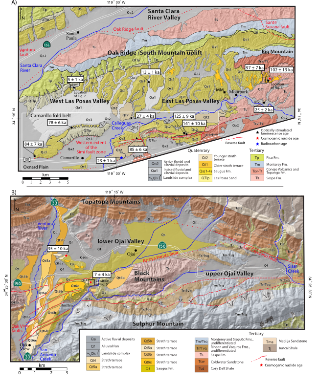
Geologic maps of the two study areas showing the distribution of Tertiary bedrock units, including the Saugus Formation, and numerical ages (white boxes). A) The Las Posas Valley and Camarillo fold belt (hollow white polygon), south of the Oak Ridge/South Mountain uplift are the main areas of focus for this study area. Plio-Pleistocene bedrock mapping was compiled from Yeats, 1988b, Dibblee, 1992a; 1992b, 1990 and modified in this study. Two distinct late Pleistocene strath terrace levels are shown (Qt1 and Qt2). A third discontinuous remnant intermediate terrace level is present, but to small to be depicted here, yet is shown in Figure 7. MM-Moorpark mammoth site. B) Geologic map of the Ojai Valley. Tertiary bedrock mapping was compiled from Dibblee 1990a and 199b, with modified Late Pleistocene strath terrace levels of Rockwell et al. (1984) shown along the Ventura River. Note that the nomenclature of Rockwell uses ascending numbers for increasing terrace age, which is the reverse for the Las Posas Valley.
Simplified index map of the principal active faults in Southern California with respect to the study areas (black boxes) draped over a topographic hillshade image. The east-west structural grain of this part of California defines the Western Transverse Ranges tectonic province with the Santa Monica fault delineating the southern boundary. Darker gray areas show the distribution of previously mapped Pleistocene Saugus Formation, which was deposited by the ancestral Santa Clara River that drains the San Gabriel Mountains. Note that many of the faults deform the Saugus Formation, which is typically the youngest unit deformed by faulting in the region. Focal mechanisms show the approximate epicenter locations for the 1971 Mw San Fernando/Sylmar, 1987, Mw6.0 Whittier Narrows, and 1994 Mw6.7 Northridge earthquakes (lower hemisphere projections). Dashed polygons show the location of selected group of strath terraces in the province that are locally faulted and folded.
Under Construction
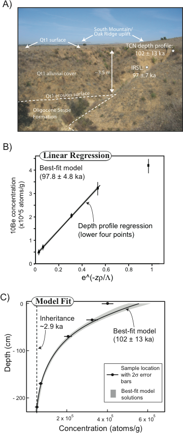
Sample location and cosmogenic nuclide data from Qt1 in the Las Posas Valley. See Figure 4a for location. A) Photograph of the sample site location showing the location of the IRSL sample and cosmogenic depth profile. The uppermost sample was excluded because it is from the surface, which has likely been modified by either bioturbation or has mixed with surface debris deposited from colluvium from the nearby hillslopes. B) Age interpretation based on traditional linear fit to data assuming an exponential decay of production rates (5.52 atoms/g/year for this site) with depth. Gray shaded area shows 2 sigma error on linear fit. C) Age results from analysis of 100,000 Monte Carlo simulations after Hidy et al. (2010). See table 3 for production rates and model parameters and text for method details. Linear and fit and Monte Carlos simulations suggest an age approximately 100 ka for the Qt1 surface.

Geochronology, paleoclimate proxy data, and sedimentation data in Southern California. Hillslope vegetation from ca. 140 ka to the present is indicated from pollen records from the Santa Barbara Channel (Heusser, 1995). Precipitation proxy data from the last 65 k.y. are inferred from paleolimnology data from lakes Baldwin and Elsinore lakes in southern California (Kirby et al., 2006; Bird and Kirby, 2006), and pollen record of Heusser (1995). See text for discussion of inferred precipitation from 140 ka to 60 ka and for links between the disparate datasets. Shaded bars show preferred age ranges for valley-bottom widening events correlated to strath terrace levels, based on interpretation of numerical results and correlation with climatic intervals. Hollow gray box boxes correlate to aggradation of Qs2, Qs3, and Qa1 in the Las Posas Valley.